Santiago de Cuba Geography
Province located in the south of Cuba’s eastern region. It has an extension of 6 162,1 sq km (2379 sq mi) and an estimated population of 1 016 754 inhabitants (1996) distributed in 9 municipalities. The province ranks eleventh in extension and second in population.
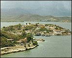
Most of the territory is covered by mountains: those of the orographic group of the Sierra Maestra, being its higher point the Turquino peak 1972 m (6468 ft); and the south portions of the Sierra de Nipe and Sierra Cristal. The rest of the territory is occupied by the eastern end of the Cauto plain, the Santiago de Cuba basin, and the central valley. The most important rivers are the Contramaestre, the Guaninicum, and the Baconao.
Insustrial activity is represented by coffee and sugar production, port activity, and cattle raising.