Pinar del Río Geography
Westernmost province of the island of Cuba. It limits to the north with the Gulf of Mexico, to the east with the province of La Habana, to the south with the Caribbean Sea, and to the west with the Yucatan Channel. It has an extension of 10 904,01 sq km (4210 sq mi) and an estimated population of 720 271 inhabitants (1996). The province ranks third in extension and seventh in population.
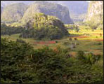
The relief of this province is characterized by the presence of the Guaniguanico mountain range, around which are located the plains of the north and south of the province, and the plain of Guanahacabibes to the southwest. The above-mentioned mountain range is divided into two different formations: the Sierra del Rosario, having the Pan de Guajaibón as maximum height with 692 m (2270 ft), and the Sierra de los Órganos. In the latter, there is a great variety of natural accidents, among which stand out the hummocks, the great cavern of Santo Tomás, and the intermountain valleys like that of Viñales, famous owing to its impressive natural beauty.
The rivers of this region are short and narrow and the most important flow towards the southern coast, like the Cuyaguateje, the Hondo, and the San Diego. There is a great deal of lagoons and dams.
Agriculture is characterized by tobacco growing, which, owing to its worldwide-renowned quality, is one of the main exports of the country. Industry is represented by fishing and wood sawmills which play an important role.