Sancti Spíritus Geography
Province located in the central region of Cuba. It has an extension of 6 732,35 sq km (2600 sq mi) and an estimated population of 451 644 inhabitants (1996). The province ranks eighth in extension and twelfth in population.
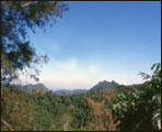 The relief presents a great diversity. In the northern section we find a narrow strip of Cuba’s central northern plain, which is interrupted by the heights of the same name and where the Sierra de Bamburanao and Meneses-Cueto outstand. More to the center we find the hills of Fomento and immediately after those of Guamuhaya. This territory comprises the eastern section of the Trinidad mountains and its highest peak, the Potrerillo, reaching 931 m (3054 ft) of height; the Agabama valley; and the western section of the Sancti Spíritus heights. To the southwest and occupying a coastal strip south from the city of Trinidad, we find the Sancti Spíritus plain, which has low and swampy zones, and going east we find the Jíbaro plain.
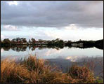 The hydrography of the province is represented by extense rivers among which the Jatibonico del Norte, Higuanojo, Yayabo, Jatibonico del Sur, and Zaza are the most important. The latter retains its waters in a dam named after the river, which is the biggest in the country.
Economical activity is characterized by cattle raising, as well as sugar and agricultural production.