Cienfuegos Geography
Province located on the south coast of Cuba’s central region. It has an extension of 4176,7 sq km (1612,6 sq mi) and an estimated population of 384 362 inhabitants (1996). The province ranks thirteenth in extension and fourteenth population. Along this region, plain zones, like Cienfuegos and Manacas plains, predominate. Those plains are located to the west and center of the province respectively while to the eastern part we find the heights of Santa Clara and the mountains of Guamuhaya, the latter having the highest point in the province and central region of Cuba, Pico San Juan (1140 m, 3739 ft) and the Martín Infierno cave treasuring a 50 m (164 ft) high and 30 m (98 ft) wide stalagmite.
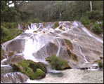
Cienfuegos’ fluvial system is represented by rivers Damují, Caunao, Arimao, Salado, and San Juan among others. Highly important are Ciego Montero mineral, medicinal, and thermal waters. Cienfuegos bay is characterized by its depth, its narrow entrance channel, and its wide interior. In addition, the waterfalls of El Nicho, located in Sierra de Trinidad mountain range, and the Guajimico zone are ideal sites for those loving nature and adventure tourism.